I have learned a lot in this class and have really enjoyed the eye opening projects and assignments we have done. I never knew how much Remote Sensing could do and how big of an impact it has on our society and world today. I think the part I enjoyed the most was the part all about the potential that droids have. It was really cool to see that they have so many different uses. From filming a birds eye view for real estate to the use in the military to keep soldiers safe and defeat potential threats to our country. Its amazing what such a simple science can do and how many fields it can be applied to. I was able to look up some of the uses of remote sensing in specific fields and I found an area that has always interested me.
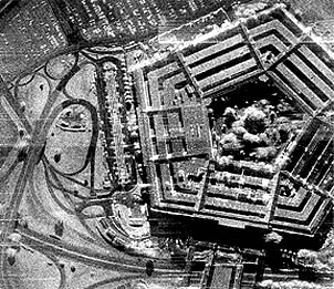
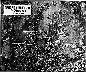
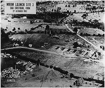
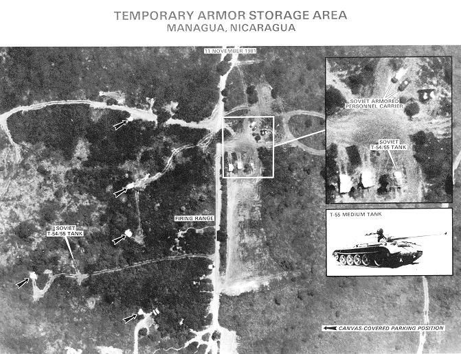
The area I was able to look more in depth into was the military field. I couldn't believe the capability and uses it has in that area. Especially with the wars going on throughout the world we can see how remote sensing truly can make a difference and an impact on the operations and defenses going on in the world. An author by the name of RD Hudson stated that "Remote sensing is the process of acquiring information from the environment by the use of a sensor that is not in physical contact with the object under study. The military services are experienced practitioners of this old, but newly glamorous, art." (Hudson, R.D., Jr. ; Hughes Aircraft Company, Culver City, Calif. ; Hudson, J.W.) I think this is a pretty cool statement. It is studying something that we aren't even in physical contact with. Thats amazing. The military has been doing this for years in many studies and has been able to overcome some very large obstacles by doing so. I can only imagine the impact it has had on saving many lives and preventing threats.
Another interesting subject i was able to find on how remote sensing helps the military is it helps with communication. As stated on the Intergraph website regarding the military geospatial technology "The integrated nature of military geospatial technology from Intergraph allows for lateral communication and data sharing in real time. Connecting all of our military geospatial technology tools, including military remote sensing and military terrain analysis, offers better decision-making capabilities through a common operational picture." In other words, this wonderful technology ultimately leads to decision-making that will benefit society and other factors. Rather then making a somewhat guess, this technology allows the military to make the right decision always.
In a textbook specifically written on the use of remote sensing in the military, author Morad Ouasti talked about the beginnings of remote sensing. "The use of remote sensing in the military area can be traced back to 1858, when Gaspar Felix Tournachon, nicknamed “Nadar”, took the first aerial photograph on a balloon. Nadar had patented the idea for taking aerial photographs for surveying. In the beginning of the 20th century pigeons, with a photograph attached to their breast, were used for military surveillance" The first photographs used for military purposes were attached to a balloon and a bird. Look how far we have come now in our world today. It is truly incredible the progress that has taken place.
I have found this subject very interesting and it has opened my mind to many amazing things that pertain to remote sensing and the peace it can bring to us in a hectic world today. Its a technology that will benefit us forever in many ways.
Course SyllabusGEOGRAHY 1780: Aerial Mapping of Earth (PS)
Instructor: R. Adam Dastrup, Associate Professor and Geosciences Coordinator
Contact Information: Canvas Learning Management System
Geosciences Department Website
REQUIRED MATERIAL
Textbook: Remote Sensing of Earth, by R. Adam Dastrup
Making Spatial Decisions Using GIS and Remote Sensing, by Kathryn Keranen and Robert Kolvoord
Supplemental website: SLCC Student ePortfolio, Canvas, and All Access
COURSE DESCRIPTION
Using the geospatial technology of satellite imagery, this hands-on course will investigate land-cover patterns of the physical and social environmental spatially and over time using remote sensing applications for analysis along with geographic information systems (GIS). The Geography Department has listed the following as its desired outcomes for students, who upon the completion of GEOG 1780 should be able to:
Students communicate effectively. This includes developing critical literacies - reading, writing, speaking, listening, visual understanding—that they can apply in various contexts; Organizing and presenting ideas and information visually, orally, and in writing according to standard usage; Understanding and using the elements of effective communication in interpersonal, small group, and mass settings.
SLCC GENERAL EDUCATION STATEMENT
This course fulfills the Physical Science requirement for the General Education Program at Salt Lake Community College. It is designed not only to teach the information and skills required by the discipline, but also to develop vital workplace skills and to teach strategies and skills that can be used for life-long learning. General Education courses teach basic skills as well as broaden a student’s knowledge of a wide range of subjects. Education is much more than the acquisition of facts; it is being able to use information in meaningful ways in order to enrich one’s life.
While the subject of each course is important and useful, we become truly educated through making connections of such varied information with the different methods of organizing human experience that are practiced by different disciplines. Therefore, this course, when combined with other General Education courses, will enable you to develop broader perspectives and deeper understandings of your community and the world, as well as challenge previously held assumptions about the world and its inhabitants.
SLCC EPORTFOLIO STATEMENT
In order for SLCC students to have a place to display and chronicle projects that demonstrate discipline-specific skills, critical thinking, and collaboration, SLCC has instituted a Gen Ed ePortfolio requirement in which students display their work from General Education courses. Students taking Gen Ed courses must place significant projects from those courses on a website they create that acts as a virtual portfolio of accomplishments in each course. In this way, prospective employers, community members, and transfer institutions can easily see the best of what each student has accomplished while attending SLCC. Your ePortfolio will allow you to include your educational goals, describe your extracurricular activities, and post your resume. When you finish your time at SLCC, your ePortfolio will then be a multi-media showcase of your educational experience. Visit http://www.slcc.edu/gened/eportfolio for more details.
You may visit the ePortfolio Lab in the basement of the Taylorsville Redwood Library during business hours, and staff will help you without an appointment. Finally, questions regarding the ePortfolio can be directed to[email protected].
GRADING SCALE
93-100 = A 90-92 = A- 87-89 = B+ 84-86 = B 80-83 = B- 77-79 = C+
74-76 = C 70-73 = C- 67-69 = D+ 64-66 = D 60-63 = D- 0-59 = E
INCOMPLETE GRADES
Students must be passing and have completed 80% of the course work in order to be granted an incomplete. Students are responsible for making arrangements to complete the course.
LATE WORK
I expect all assignments and discussions to be turned in on time. Late work will not be accepted unless you are maimed, very sick, or otherwise incapable of using your fingers or your brain. If you experience such calamities, you may ask for an extension – providing documentation.
ONLINE PARTICIPATION AND ATTENDANCE
For this course participation is attendance. Simply filling an “electronic” seat space is not participating in the class. In my view, being “intellectually absent” from class discussions/activities is no different than being physically absent for class. I expect you to come to log into Canvas DAILY, read the assigned textbook chapters, and engage in online class discussions/activities.
PLAGIARISM
Students commit plagiarism when they submit another person’s work as their own. Plagiarism also includes the failure to attribute unique phrases, passages, or ideas to their original source (I will not grade any papers that do not contain both in-text and Works Cited citations). Plagiarism is a violation of the student code of conduct. Students who commit plagiarism will receive either an automatic E for that assignment or an E for the course, depending upon the severity of the plagiarism.
ACCOMMODATION FOR STUDENTS WITH DISABILITIES
Students with medical, psychological, learning or other disabilities desiring accommodations or services under ADA, must contact the Disability Resource Center (DRC ). The DRC determines eligibility for and authorizes the provision of these accommodations and services for the college." Please contact the DRC at the Student Center, Suite 244, Redwood Campus, 4600 So. Redwood Rd, 84123. Phone: (801) 957-4659, TTY: 957-4646.
Instructor: R. Adam Dastrup, Associate Professor and Geosciences Coordinator
Contact Information: Canvas Learning Management System
Geosciences Department Website
REQUIRED MATERIAL
Textbook: Remote Sensing of Earth, by R. Adam Dastrup
Making Spatial Decisions Using GIS and Remote Sensing, by Kathryn Keranen and Robert Kolvoord
Supplemental website: SLCC Student ePortfolio, Canvas, and All Access
COURSE DESCRIPTION
Using the geospatial technology of satellite imagery, this hands-on course will investigate land-cover patterns of the physical and social environmental spatially and over time using remote sensing applications for analysis along with geographic information systems (GIS). The Geography Department has listed the following as its desired outcomes for students, who upon the completion of GEOG 1780 should be able to:
Students communicate effectively. This includes developing critical literacies - reading, writing, speaking, listening, visual understanding—that they can apply in various contexts; Organizing and presenting ideas and information visually, orally, and in writing according to standard usage; Understanding and using the elements of effective communication in interpersonal, small group, and mass settings.
- Apply basic cartographic design rules for clear, visual communication os spatial data.
- Clearly discuss a variety of topics related to geospatial technology in regards to privacy, ethics, environmental monitoring, geopolitics and more.
- Describe basic physics concepts on which remote sensing is based upon.
- Perform basic remote workflows to solve problems (such as acquiring data, feature extraction, change detection, pre- and post-processing, create composite images, and image classification.
- Interpret, analyze, and summarize results in a remote sensing workflow.
- Discover how to select appropriate data sets for remote sensing applications based on spectral, temporal, radiometric, and spatial resolution.
- Compare the characteristics of passive and active remote sensing systems.
- Discover the variety of ways remote sensing is used in society along with future trends.
SLCC GENERAL EDUCATION STATEMENT
This course fulfills the Physical Science requirement for the General Education Program at Salt Lake Community College. It is designed not only to teach the information and skills required by the discipline, but also to develop vital workplace skills and to teach strategies and skills that can be used for life-long learning. General Education courses teach basic skills as well as broaden a student’s knowledge of a wide range of subjects. Education is much more than the acquisition of facts; it is being able to use information in meaningful ways in order to enrich one’s life.
While the subject of each course is important and useful, we become truly educated through making connections of such varied information with the different methods of organizing human experience that are practiced by different disciplines. Therefore, this course, when combined with other General Education courses, will enable you to develop broader perspectives and deeper understandings of your community and the world, as well as challenge previously held assumptions about the world and its inhabitants.
SLCC EPORTFOLIO STATEMENT
In order for SLCC students to have a place to display and chronicle projects that demonstrate discipline-specific skills, critical thinking, and collaboration, SLCC has instituted a Gen Ed ePortfolio requirement in which students display their work from General Education courses. Students taking Gen Ed courses must place significant projects from those courses on a website they create that acts as a virtual portfolio of accomplishments in each course. In this way, prospective employers, community members, and transfer institutions can easily see the best of what each student has accomplished while attending SLCC. Your ePortfolio will allow you to include your educational goals, describe your extracurricular activities, and post your resume. When you finish your time at SLCC, your ePortfolio will then be a multi-media showcase of your educational experience. Visit http://www.slcc.edu/gened/eportfolio for more details.
You may visit the ePortfolio Lab in the basement of the Taylorsville Redwood Library during business hours, and staff will help you without an appointment. Finally, questions regarding the ePortfolio can be directed to[email protected].
GRADING SCALE
93-100 = A 90-92 = A- 87-89 = B+ 84-86 = B 80-83 = B- 77-79 = C+
74-76 = C 70-73 = C- 67-69 = D+ 64-66 = D 60-63 = D- 0-59 = E
INCOMPLETE GRADES
Students must be passing and have completed 80% of the course work in order to be granted an incomplete. Students are responsible for making arrangements to complete the course.
LATE WORK
I expect all assignments and discussions to be turned in on time. Late work will not be accepted unless you are maimed, very sick, or otherwise incapable of using your fingers or your brain. If you experience such calamities, you may ask for an extension – providing documentation.
ONLINE PARTICIPATION AND ATTENDANCE
For this course participation is attendance. Simply filling an “electronic” seat space is not participating in the class. In my view, being “intellectually absent” from class discussions/activities is no different than being physically absent for class. I expect you to come to log into Canvas DAILY, read the assigned textbook chapters, and engage in online class discussions/activities.
PLAGIARISM
Students commit plagiarism when they submit another person’s work as their own. Plagiarism also includes the failure to attribute unique phrases, passages, or ideas to their original source (I will not grade any papers that do not contain both in-text and Works Cited citations). Plagiarism is a violation of the student code of conduct. Students who commit plagiarism will receive either an automatic E for that assignment or an E for the course, depending upon the severity of the plagiarism.
ACCOMMODATION FOR STUDENTS WITH DISABILITIES
Students with medical, psychological, learning or other disabilities desiring accommodations or services under ADA, must contact the Disability Resource Center (DRC ). The DRC determines eligibility for and authorizes the provision of these accommodations and services for the college." Please contact the DRC at the Student Center, Suite 244, Redwood Campus, 4600 So. Redwood Rd, 84123. Phone: (801) 957-4659, TTY: 957-4646.
